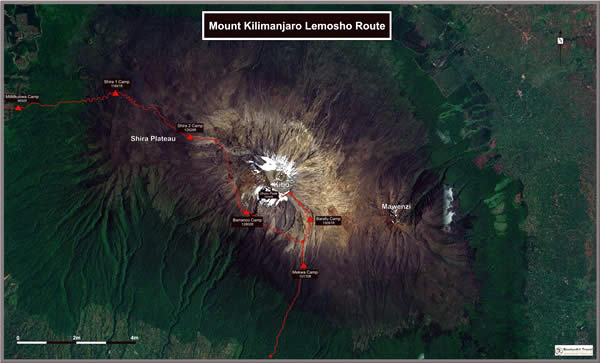
Lemosho Route
Lemosho is the longest of the outfield routes, and sometimes regarded as the second timers Kilimanjaro route, although it is also for anyone with an appetite for a quieter trail and a more remote atmosphere. Some would say that the beauty of the trail is a little less accessible than Machame, and certainly the rolling Shira Plateau that is one of the principal features of the trail adds an interesting texture quite as it allows for a more moderate process of acclimatization. Lemosho also has the added potential of big game sighting on the lower reaches, requiring sometimes that the first day be hiked in the company of an armed game scout.
The climb itself can take either 7 or 8 days, with 8 days being recommended in order that climbers have more opportunity to acclimate before the brutal summit day. This route is not nearly as popular as Machame or Maragnu, but it’s a good one to consider because the longer climbing time equals a greater chance of reaching the summit with fewer problems.
The Lemosho trailhead is situated well west of the other routes, but from day 4 onwards it merges with Machame and follows the same course from then on. And quite as most Machame groups descend on the separate Mweka Route, Lemosho groups typically do as well.
It takes about 3 hours to drive from Moshi to the official trailhead. Below is the normal 8-day itinerary, with a note about the 7-day version below:
Day 1:
Londorossi Gate to Mti Mkumbwa (2,650 m/8,692 ft)
Hike time: 3hrs
Elevation Change: + 650 M/+2,132
Estimation distance: 10 km
Final Elevation: 2,650 m/8,694 ft
After the morning drive to the trailhead you’ll spend the first day with an armed ranger due to the animal population in this forest area, stopping at the Mti Mkumbwa Camp after only about 3 hours of climbing.
Day 2:
Mti Mkubwa (2,650 m/8,692 ft) to Shira One Camp (3,609 m/11,841 ft.)
Hike time: 5 – 6 hrs
Elevation change: + 950 M/+3116
Estimation distance: 12 km
Final Elevation: 3609 m/11,841 ft
This day starts in the forest and gets considerably steeper as you go through the heather and moorland areas before camping at the Shira Plateau in a large, open, and scenic area at the Shira One Camp.
Day 3:
Shira One Camp (3,609 m/11,841 ft.) to Shira Two Camp (3,849 m/12,628 ft.)
Hike time: 5 – 6 hrs
Elevation change: + 240 M/+787 ft
Elevation distance: 5 km
Final elevation: 3849 m/12,628 ft.
This day takes you on a gentle walk across the plateau for some excellent scenery while your body continues to acclimatize.
NOTE: From Shira Two Camp on, this route is identical to Machame Route, including the descent on the separate Mweke Route. If you’ve taken Lemosho you’ve done another day at this point, so Day 4 of Lemosho is identical to Day 3 of Machame and so on.
Day 4:
Shira Two Camp (3,849 m/12,628 ft.) to Barranco Hut (3,948 m/12,956 ft.)
Hike time: 5 hrs
Elevation change: +100 M/+328 ft
Estimated distance: 6 km
Final elevation: 3948 m/12,956 ft.
The morning climb is somewhat steep on this day as you ascend to Lava Tower at 4,600 meters at midday before descending again on the scenic route to Barranco Camp. This is a great example of the climb high/sleep low rule that helps people acclimatize safely.
Day: 5
Barranco Hut (3,900 m/12,800 ft) to Karanga Valley (3,963 m/13,000 ft)
Hike time: 3.5 hrs
Elevation change: +100 m/+328 ft
Estimated distance: 4km/2.5 miles
Final elevation: 3,963 m/13,000 ft
You climb the Great Barranco Wall, which looks more intimidating than it really is, and down into the Karanga Valley. This day has many ups and downs and crosses many small streams before crossing the Karanga River just before camp.
Day 6:
Karanga Valley (3,963 m/13,000 ft) to Barafu Hut (4,600 m/15,091 ft)
Hike time: 3.5 hrs
Elevation change: +600 m/+1,968 ft
Estimated distance: 4km/2.5 miles
Final elevation: 4,600 m/15,091 ft
You climb through rocky and otherwise barren terrain on your way to Barafu Camp. The camp is in another cold and windy area, but you’ll only be sleeping from around 7 p.m. until 11: 30 p.m. or so because you’ll be starting the summit climb at midnight.
Day 7:
Barafu Camp (4,600m/15,091 ft) to The Summit (5,896 m/19,343 ft) and then to Mweka Camp (3,100 m/10,170 ft)
Summit time: 7 hrs
Elevation change: +1,300 m/+4,265 ft
Estimated distance: 5km/3.2 miles
Final elevation: 5,896 m/19,343 ft
Descent time: 5 hrs
Elevation change: -2,800 m/-9,186 ft
Estimated distance: 12km/7.5 miles
Final elevation: 3,100 m, 10,170 ft
You’ll start at midnight with by far the most challenging 6-hour section of entire climb as you reach Stella Point around sunrise. After a short rest you’ll probably be walking in snow for the next two hours until you reach Uhuru Peak, AKA the summit! After enjoying the moment briefly you’ll begin your descent to the Mweka Camp back in the rain forest, which takes about 8 hours including a quick rest in the middle.
Day 8:
Mweka Hut (3,100 m/10,170 ft) to Mweka Gate (1,828 m/6,000 ft)
Descent time: 4 hrs
Elevation change: -1,250 m/-4,101 ft
Estimated distance: 10km/6.21
Final elevation: 1,828 m/6,000 ft
After the previous day you’ll deserve this short and very scenic descent of about 4 hours down to the Mweka Gate, where you’ll sign the register to make your climb official.
The 7-day version of Lemosho
You can do the Lemosho in 7 days instead of 8, and the only difference is days 2 and 3 on the 8-day climb are combined into one 8 to 9 hour climb from Mti Mkubwa to the Shira Two Camp. This extra day is obviously more challenging and it also cuts way down on the climbers’ acclimatization time, which can hurt the chances of reaching the summit with fewer problems.
