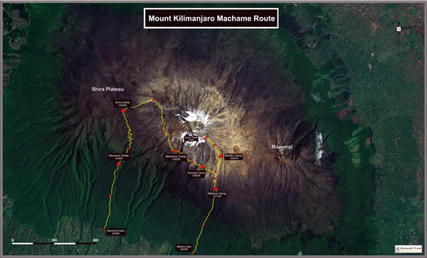
Machame Route
Also known as the ‘Whisky Route’, no doubt in order to set it apart from the ‘Coca Cola’Marangu route as an option not for the soft-core, Machame is probably the easiest of the outfield routes, and is widely regarded as the most scenic route on the mountain. It is usually completed in either 6 or 7 days, with 7 being the norm thanks to the obvious advantage of an extra day of altitude adjustment. For those choosing a 6-day option prepare for a couple of taxing 10-hour pushes.
Another great advantage to using Machame Route is the fact that the first few days see a substantial gain in elevation that eases the altitude stress on over the days following, and in particular preceding the brutal summit push. Descent is usually via the Mekwa route. About 40 percent of those climbing Kilimanjaro use this route.
The day begins with a check in at the Machame Gate office, and then either a walk or a short drive about 2.5 kilometers to the official trailhead depending on road conditions, which are often too muddy for vehicles.
Below is the itinerary for the recommended 7-day climb on the Machame Route, with a note about the 6-day version below:
Day 1:
Machame Gate (1,634 m/5,363 ft) to Machame Hut (2,834 m/9,300 ft)
Hike time: 7.5 hrs
Elevation change: +1,200 m/+3,937 ft
Estimated distance: 10km/6.21 miles
Final elevation: ,3100 m/10,170 ftIntitially the trails threads through cloud forest and it is not improbable that you will be climbing in rain and mud most of the day before arriving at Machame Camp in late afternoon. Conditions on this day are fairly steep which achieved an elevation wherein your body will begin to feel the early effects of altitude.
Day 2:
Machame Hut (2,834 m/9,300 ft) to Shira Hut (3,749 m/12,300 ft)
Hike time: 7 hrs
Elevation change: +800 m/+3,000 ft
Estimated distance: 6km/3.75 miles
Final elevation: 3,800 m/12,467 ftThe trail emerged early from the cloud forest and most of the day is spent on moorlands before reaching the famous views of the Shira Plateau and later the Shira Camp. The climb on this day is not as steep as the day previous, but this night is likely to be cold- probably a little below freezing.
Day 3:
Shira Hut (3,749 m/12,300 ft) to Barranco Hut (3,901 m/12,800 ft)
Hike time: 5 hrs
Elevation change: +100 m/+328 ft
Estimated distance: ?
Final elevation: 3,900 m/12,800 ftThe morning climb is somewhat steep on this day as you climb to Lava Tower at 4,600 meters at midday before descending again on the scenic route to Barranco Camp. This is a great example of the climb high/sleep low rule that helps people acclimatize safely.
Day 4:
Barranco Hut (3,900 m/12,800 ft) to Karanga Valley (3,963 m/13,000 ft)
Hike time: 3.5 hrs
Elevation change: +100 m/+328 ft
Estimated distance: 4km/2.5 miles
Final elevation: 3,963 m/13,000 ftYou climb the Great Barranco Wall, which looks more intimidating than it really is, and down into the Karanga Valley. This day has many ups and downs and crosses many small streams before crossing the Karanga River just before camp.
Day 5:
Karanga Valley (3,963 m/13,000 ft) to Barafu Hut (4,600 m/15,091 ft)
Hike time: 3.5 hrs
Elevation change: +600 m/+1,968 ft
Estimated distance: 4km/2.5 miles
Final elevation: 4,600 m/15,091 ftToday the route moves through rocky and otherwise barren terrain on your way to Barafu Camp. The camp is in another cold and windy area, but you’ll only be sleeping from around 7 p.m. until 11: 30 p.m. or so thanks to the summit climb commencing at midnight.
Day 6:
Barafu Camp (4,600m/15,091 ft) to The Summit (5,896 m/19,343 ft) and then to Mweka Camp (3,100 m/10,170 ft)
Summit time: 7 hrs
Elevation change: +1,300 m/+4,265 ft
Estimated distance: 5km/3.2 miles
Final elevation: 5,896 m/19,343 ft
Descent time: 5 hrs
Elevation change: -2,800 m/-9,186 ft
Estimated distance: 12km/7.5 miles
Final elevation: 3,100 m, 10,170 ftToday kicks off at midnight with by far the most challenging 6-hour section of entire climb as you reach Stella Point around sunrise. After a short rest you’ll probably be walking in snow for the next two hours until you reach Uhuru Peak, AKA the summit! After enjoying the moment briefly you will begin your descent to the Mweka Camp back under cover of the cloud forest, about and 8 hour trek including a quick rest midway.
Day 7:
Mweka Hut (3,100 m/10,170 ft) to Mweka Gate (1,828 m/6,000 ft)
Descent time: 4 hrs
Elevation change: -1,250 m/-4,101 ft
Estimated distance: 10km/6.21
Final elevation: 1,828 m/6,000 ftAfter the previous day you’ll deserve this short and very scenic descent of about 4 hours down to the Mweka Gate, where you’ll sign the register to make your climb official.
The 6-day version
On 6-day climbs on the Machame Route days 4 and 5 are combined into one. Again, as appealing as it might sound to go up as fast as possible, the experienced guides recommend taking the extra day. It not only lets you enjoy the scenery longer, but statistics show climbers have a better chance of safely reaching the summit with the extra day to acclimatize.
